Neel Kamal Chapagain's Thoughts and Reflections
- बेइजिंग (चीन)मा अरनिकोको श्वेत चैत्य | January 7, 2026
- जलवायु परिवर्तन सम्बन्धी थामेले गराएको ध्यानाकर्षण!!! | December 13, 2025
- Waking up to the climate change | December 13, 2025
- Declaring DoA&NA building as ‘heritage’ and implications for the Department of Archaeology | October 3, 2025
- माफ गर्नुहोला आर्किटेक्ट महोदयहरु!!! | September 27, 2025
- Sorry, Architects!!! | September 26, 2025
- भग्नावशेषलाई सम्पदाको रुपमा हेर्दा: मेरो विचारमा अबको बाटो | September 20, 2025
- भग्नावशेष, हामी, र भविष्य | September 12, 2025
Waking up to the Climate Change:
Thame’s call for attention to Climate Change!!!
Neel Kamal Chapagain
13 December 2025
It has been two months since I wrote my last blog and this lapse has primarily been due to my travels for professional meetings and conferences - from Seoul to Delhi, Shanghai to Singapore, Lumbini to Lukla, and frequent trips between Kathmandu and Kavre. Almost all of these meetings had the climate change as an important theme to reflect upon, but it was the trip to Thame last month that gave me a real wake up call about climate change. The awakening trip to the Khumbu region – officially the Sagarmatha National Park (Sagarmatha is the Nepali name for Mt Everest) took place in mid November. Although we were told that the tourist season was wrapping up, I was impressed with the number of tourists and the tourism infrastructure and management in this region as compared to other regions in Nepal. The journey of transformation for the region began in 1953 with the successful ascend to Sagarmatha by Edmund Hillary and Tenzing Norgay Sherpa, which promoted mountaineering followed by trekking tourism in the region. However, the impacts of tourism, the beauty as well as burden of not having motor roads (while rest of the rural municipalities across Nepal have built roads in an unprecedented rate), the legacy of the national park that too as a world heritage site etc. had several lessons one could absorb. Yet, this trip to Thame hit me hard about my own superficial engagement with the theme of climate change until now. Hence, I have pledged that I will engage with the issue of climate change with a much more grounded approach. This blog is just a pretext to my realization.
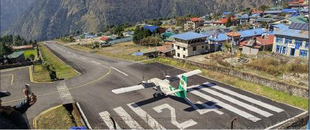
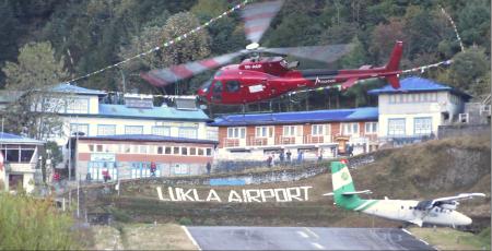
On 10 November 2025, we landed at the Tenzing Hillary Airport at Lukla at an altitude of 2845 metres from the mean sea level (msl) – the starting point of our journey in the Khumbu region. The airport has been on my watch list due to its terrain and the plane spotting experience. So, I spent some time spotting a few take offs and landings before we began our trek. I resume the plane watching up on our return as well – I actually walked down to the end of the runway at the cliff side to watch the take off and landing from that side as well. This is an experience worth watching to get a sense of the terrain of our country. Although usually dubbed as one of the most dangerous airports in the world, I wish to appreciate the courage and creativity that went behind this infrastructure. Edmund Hillary’s commitment to help the communities in this region should be a reminder to us – professionals who engage with a community or place as a mandate of their work but usually do not commit any further than what is expected of us in a mission. So, to me the Lukla airport was both a personal interest and a professional inspiration.
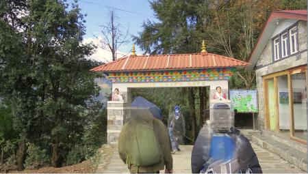
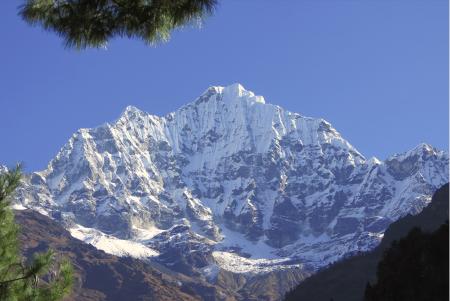
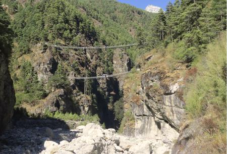
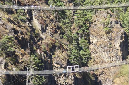
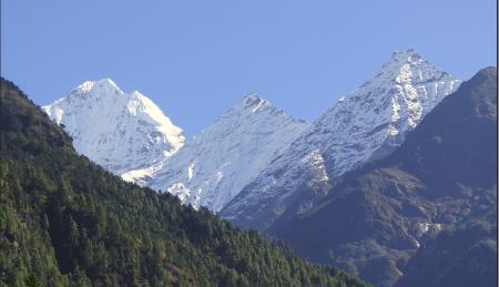
My pastime of plane spotting aside, my exploration in Lukla and then the three days trek forward has been in the intersections of Himalayan cultural landscapes, the mountaineering industry following the Tenzing-Hillary successful expedition to the Everest in 1953, and the discourse of cultural heritage in the area primarily known as the Sagarmatha National Park – a World Heritage Site (Natural Heritage criteria) since 1979. Embedded within such exploration is the key concern about people, culture and sustainability amidst tourism, environmental concerns, developmental aspirations and the challenges of climate change. However, this is not an academic paper but just a blog capturing the contexts that has led me to look into these discourses.
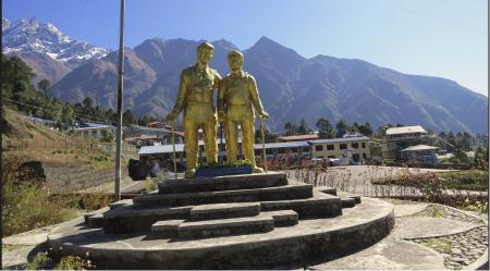
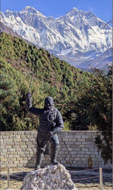
Considered as the gateway to the Everest, this particular short take off and landing (STOL) airport is interesting as the landing planes get slow down process aided by an upward slope of the runway. The take off, however, seems scary due to a downward slope that starts seemingly with a slight but sudden drop as you can notice if you watch a plane starting to take off on the runway 24. The hotel Runway 24 is very appropriately named so, and I enjoyed a night stay there on the return. It is said that Edmund Hillary was instrumental behind this airport, and finally it is named after him and Tenzing rightly in 2008. A statue of the duo watches the plane come and go at the airport in Lukla. Beyond that there are few other memorials for them, for example - the Hillary bridge on the way to Namche and the Tenzing statue at the view point next to the headquarters of the Sagarmatha National Park in Namche keep reminding us of their legacy.
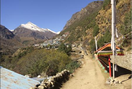
Everything has its positive and negative aspects. In the hindsight today, the Tenzing-Hillary expedition may be criticized for exposing the Everest and its peers to today’s unprecedented human crowding and environmental issues, but it is also clear that it brought in tangible changes and opportunities to the Sherpa communities as well. Had there been the buzz word of climate change back in the 1953, I would assume Tenzing and Hillary would have also flagged it from the top of the world for our attention. Nonetheless, I appreciate Hillary’s sense of ethics towards the people and environment, and Lukla airport (Tenzing-Hillary airport) was also an outcome of Hillary’s gesture for serving the local people. However, today the aviation at the Lukla airport has also been an example of disparity between the dollar fare paying people and ordinary Nepali people. So many of such issues we could touch upon, but our ultimate destination was actually Tenzing Norgay’s birth place, Thame – at an altitude of 3800 metres and a three day journey for us after landing at Lukla. In fact, Thame is the home to many famous Sherpas who had been known for their legacies on mountaineering, including Apa Sherpa, Kami Rita Sherpa, Ang Rita Sherpa and others. Likewise today, it is home to Dr. Kami Temba Sherpa – the first doctor of the Khumbu region, Mrs Ang Dami Sherpa – the record holding multiple winner of the Everest Marathon. She won the marathon even during her pregnancy.
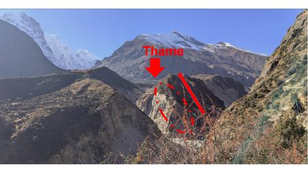
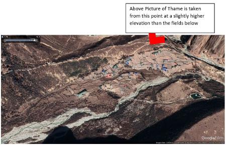
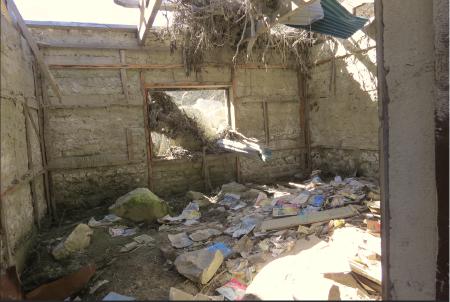
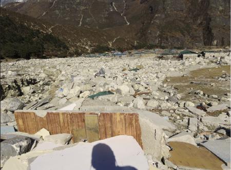
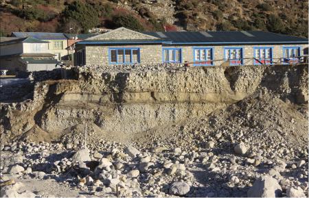
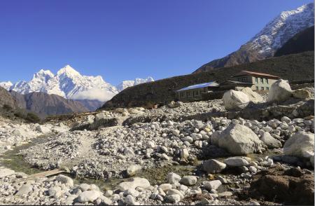
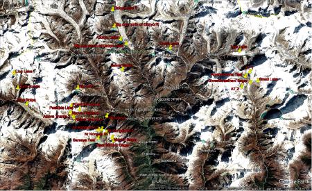
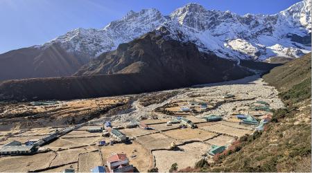
On this backdrop, I draw your attention to Thame on 16 August 2024 – 15 months before our visit. On that unfortunate afternoon, some of the villagers heard a strange roaring sound from upstream of the Thame river and the valley, and some of them pinned down that something is coming from upstream. It was a massive flood not just with water but a lot of debris including big boulders and rocks from the upstream landscapes. There were no rains around that time, so initially it was guessed that it might have been caused by a sudden release of water from a landslide caused blockage of the river. Later it became clear that it was actually a burst of a glacier lake that further trigger burst of a second lake out of the four lakes that were there upstream from Thame. Many accounts are published of this GLOF in the aftermath, for example – this one by ICIMOD . This youtube video has the accounts of people, many of whom I met during my visit last month.
A school full of students was timely evacuated along with all the villagers who were there in their houses or vicinity that afternoon. Amidst the devastation caused by the GLOF, one consoling fact was that there were no human casualty. A three day long prayers – as a traditional practice, was organized to ease the pain of the disaster. I believe that the monks and the monasteries hold a worldview about nature and human world that has much to teach us about our relation as well as position in nature, and how we should build resilience. They are of the age-old opinion that such disasters are bound to happen, but our prayers (I take it metaphorically to relate to our sincere and ethical activities with regards to the environment as well) can help mitigate the impact such as the prevention of loss of life during the 2024 GLOF.
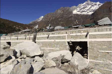
The interactions with the residents of Thame inspired me to think of resilience in a much more grounded way. While they must have cried and panicked, they accepted the wrath of nature as what was bound to happen and moved on with life. Some of them have rebuilt some parts of their houses as well as guest houses, and tourism is back although seemingly in a smaller scale this year. Agricultural land, grassland and some ritualistic places are lost to the flood but the spirit of a living culture is what makes Thame rise from the GLOF. The warm hearted people still find one thing or the other in the deserted landscape with big boulders that are hard to move around. During our interaction on site, we noticed them picking up – for example a spoon I clicked a picture of, that would remind them of their pre-GLOF material possession and memories. These were emotional moments and very difficult to handle, yet they shared with us their courage and wisdom to evacuate all of them to the higher grounds, and watch painfully as their homes got engulfed by the roaring stream of water, mud, boulders and so on. One can browse through reels and news shared through various media platforms, but I am not sure if such media clips have triggered any awakening to rest of the human world. This is where I think an ‘experiential pilgrimage’ (I need to write a paper on this) to such places are perhaps necessary to most of us to awaken our minds and eyes. These are also pivotal points to rethink the notion of disaster preparedness and resilience.
There are many stories to get some inspirations from the people who survived this unforecasted GLOF. Apparently researchers working on the cryosphere have prepared the list of potentially dangerous glacier lakes in the Himalayas, but the ones that caused the disaster in 2024 were not even flagged for being at risk. That means to me that science and scientists too have a long way to go about predicting the risks. In such a scenario, I think the wisdom of the monks have a lot to alert us but we hardly pay attention to them. For me, a different heritage of resilience as well as resilience with heritage emerge from these experiences, and we must engage with these Himalayan cultural discourses.
We were there only for a few days but it felt like we were taught lessons of a lifetime. We came back with a bit of grounded understanding about climate change, and felt the hovering crisis over us – from which no one has easy escape. So, we must pay attention to the impending impacts of climate change, whether we live upstream or downstream or seemingly far from any streams, climate change is just above us. I am scared to realize we are already running late, but let’s hope it is better late than never to wake up. Climate change is a common concern and we need to adjust ourselves in every aspect of what we do because we may be contributing to the green house gas emission from the kind of food we eat, to the way we travel, to the other aspects of everyday life and so on. Yet, another sad reality is we – Nepali or communities in the Himalayan region, are the least contributor to the causes of global warming and climate change, yet we seem to be at the brink of serious impacts including so many glaciers that are in the verge of melting and outburst. It is an urgent issue and we all need to ponder upon it. I have finally awaken to this looming threat, and wish to alert you all through this blog. I will keep sharing any further knowledge and insights I gain, and I hope to work with others who have already taken a further steps towards mitigating the impact of such global scale.
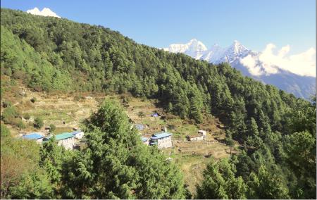
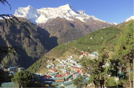
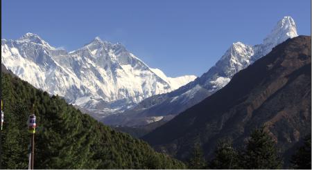
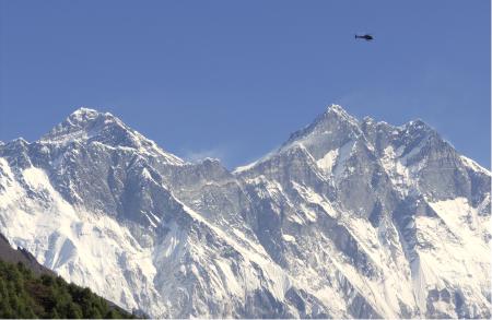
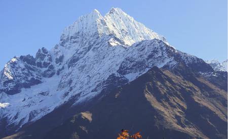
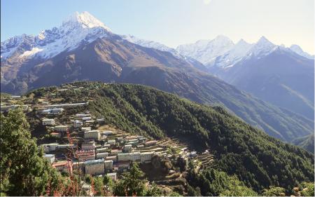
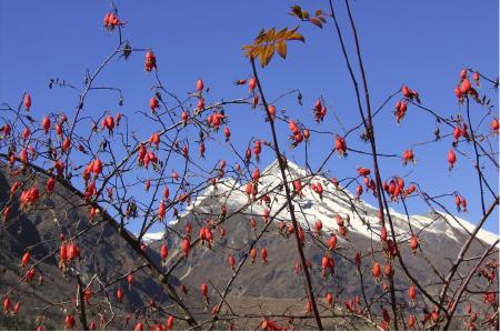
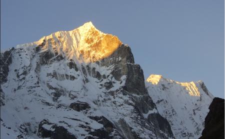
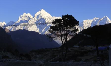
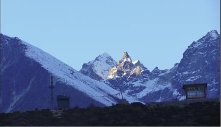
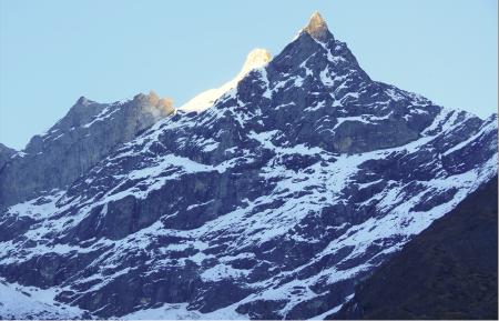
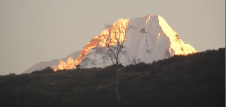
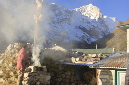
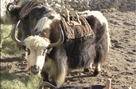
The pictures below speak better than my words. I hope they speak to you as well unless you have already been to these places and seen/experienced for yourself.